Trip Report: Winter Break in Mexico
- Read Brooke Ballard’s report on the Mexico trip »
- Read Taylor Dishner’s report on the Mexico trip »
- Read Cassandra Finney’s report on the Mexico trip »
- Read Nicole Heineken’s report on the Mexico trip »
- Read Benjamin Hopkin’s report on the Mexico trip »
- Read Grayson Jones’ report on the Mexico trip »
- Read Sid Mahajan’s report on the Mexico trip »
- Read Jordan Sutton’s report on the Mexico trip »
- Read Christopher Walker’s report on the Mexico trip »
The Tickle College of Engineering Global Initiatives program embarked on its 14th trip for the Alternative Winter Break, 2016, to the Yucatán Peninsula, Mexico. Taking part in the trip were Chemical Engineering majors Brooke Ballard, Cassandra Finney, Nicole Heineken, Benjamin Hopkins, Grayson Jones, Sid Mahajan, and Maggie Mann; Material Science majors Christopher Walker, Andrew Ten Eyck, and Jordan Sutton; Mechanical majors Kea Francis, and Victoria Idem; Civil major Morgan Jenkins, Nuclear major Kalie Knecht, and Accounting major Taylor Dishner. Senior Supply Chain Management major Carmen Philpot served as co-leader of the trip, which took place from December 16 – 23, 2016.
The group met the in-country coordinator, Ms. Ana Maria Videz in Cancún (from the Mayan for “snakes’ nest.”) She collected everyone at the airport for transport to the hotel where the group would spend the first night before starting the tour of the Yucatán Peninsula the following day.
The next morning, the group set out for the Colonial town of Mérida. Since the drive was several hours long, a few stops were scheduled. The first of these was at the Playa Delfines, or Dolphin Beach, purportedly the most beautiful beach in Cancún, on the Caribbean Sea. Red flags, the most serious of all beach warning flags, indicated that the surf was high or there were dangerous currents, or both. The next stop was lunch at a rural and traditional Mayan restaurant complete with dancers who could balance bottles on their heads. Once in Mérida, the group visited the Gran Museo del Mundo Maya, or the Museum of the Mayan World, an anthropological exhibits archive. Starting with an interpretive video in Spanish, history from the time of the meteor hitting earth and causing the extinction of the dinosaurs throughout the time of the Mayan people was overviewed. Several pterodactyl skeletons are displayed overhead in the lobby. All significant manner of Mayan history and culture are covered, including tools, fossils, masks, insects, birds, mammals, information on metals, costumes, and more. Several of the garments displayed feature extremely elaborate cross-stitch designs which have been handed down through the generations.
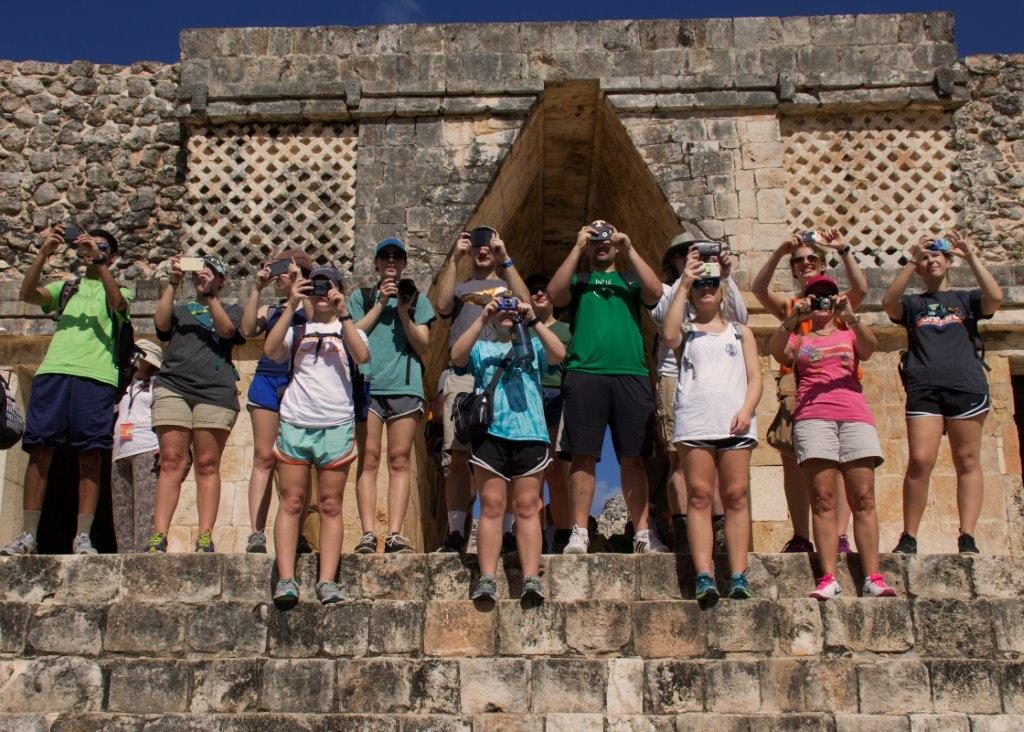
Nearby Mérida are the archaeological ruins of Uxmal, where the group had a guided visit with a native expert. Uxmal is an ancient Maya city of the classical period. It is considered one of the most important archaeological sites of Maya culture, located in the Puuc region and is one of the Maya cities most representative of the region’s dominant architectural style. It has been designated a UNESCO World Heritage Site. Its buildings are typical of the Riley Kand Puuc style. Entwined snakes and, in many cases two-headed snakes, are used for masks of the rain god, Chaac. Feathered serpents with open fangs are shown leaving from the human beings depicted in stone. The buildings take advantage of the terrain to gain height, including the Pyramid of the Magician, with five levels, and the Governor’s Palace, which covers an area of more than 1,200 m2 (12,917 sq. ft.). The present name seems to derive from Oxmal, meaning “three times built”.
Close by Uxmal and lesser known but equally as impressive, is the site of Kabah, usually taken to be archaic Maya language for “strong hand”. This is a pre-Columbian name for the site, mentioned in Maya chronicles. An alternative name is Kabahaucan or “royal snake in the hand”.
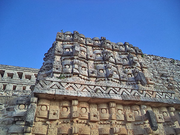
The area was inhabited by the mid-3rd century BCE. Most of the architecture now visible was built between the 7th century and 11th centuries CE. A sculpted date on a doorjamb of one of the buildings gives the date 879, probably around the city’s height. Kabah was abandoned or at least no new ceremonial architecture built for several centuries before the Spanish conquest of the Yucatán. The most famous structure at Kabah is the “Palace of the Masks”, the façade decorated with hundreds of stone masks of the long-nosed rain god and protector of the harvest, Chaac; the massive repetition of a single set of elements is unusual in Maya art. Interestingly, only about 30% of Kabah has been reclaimed; the rest remains protected under layers of soil and vegetation.
Another Colonial town, Valladolid, was next on the map. On the way there, the group stopped in a smaller Colonial township, Izamel. The town was continuously occupied throughout most of Mesoamerican chronology; Izamal is known in Yucatán as the Yellow City as most of its buildings are painted a mustard-yellow color, and the City of Hills, for the practice of building newer structures atop ancient temple pyramids. A primary feature of the town, which the group visited, is el Convento de Izamel, or the Convent of Our Lady of Izamel, which boasts the second-largest atrium in the world, after that of St. Peter’s Square. Nuns and monks of the Franciscan order live at the convent, which was constructed atop Mayan ruins.
The largest archaeological site visited on the trip was the ancient city and architectural ruins of Chichén Itzá meaning “at the mouth of the well of the Itza people”; Itzá is the name of an ethnic-lineage group that gained political and economic dominance of the northern peninsula. Chichén Itzá was a large pre-Columbian city built by the Maya people of the Terminal Classic period. It functioned as a town from about 600 A.D. to 1200 A.D. and was a major economic power in the northern Maya lowlands during its apogee. About 1.4 million people visit the site each year. The site contains many fine stone buildings in various states of preservation, and many have been restored. The buildings were connected by a dense network of paved causeways, called sacbeob. Archaeologists have identified over 80 sacbeob crisscrossing the site and extending in all directions from the city. The architecture encompasses a number of styles, including the Puuc and Chenes styles of the northern Yucatán Peninsula. The buildings are grouped in a series of architectonic sets, and each set was at one time separated from the other by a series of low walls. One of these complexes is the Great North Platform, which is dominated by the monuments of El Castillo (the pyramid or Temple of Kukulkan, a Maya feathered serpent deity similar to the Aztec Quetzalcoatl), Temple of Warriors, and the Great Ball Court. The step pyramid of Kukulkan stands about 30 metres (98 ft) high and consists of a series of nine square terraces, each approximately 2.57 metres (8.4 ft) high, with a 6-metre (20 ft) high temple upon the summit. Due to wear and tear from tourism, visitors are no longer allowed to climb the pyramid. The sides of the pyramid are approximately 55.3 metres (181 ft) at the base and rise at an angle of 53°, although that varies slightly for each side. The four faces of the pyramid have protruding stairways that rise at an angle of 45°. At the base of the balustrades of the northeastern staircase are carved heads of a serpent.
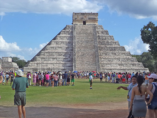
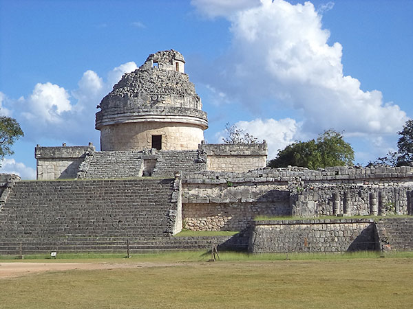
Mesoamerican cultures periodically superimposed larger structures over older ones, and El Castillo is one such example. In the mid-1930s, the Mexican government sponsored an excavation of the pyramid, and after several false starts, they discovered a staircase under the north side of the pyramid. By digging from the top, they found another temple buried below the current one. On the Spring and Autumn equinoxes, in the late afternoon, the northwest corner of the pyramid casts a series of triangular shadows against the western balustrade on the north side that evokes the appearance of a serpent wriggling down the staircase, which some scholars have suggested is a representation of the feathered-serpent god Kukulkan. Archaeologists have identified thirteen ball courts for playing the Mesoamerican ballgame in Chichén Itzá, but the Great Ball Court about 150 metres (490 ft) to the north-west of the Castillo is by far the most impressive. It is the largest and best preserved ball court in ancient Mesoamerica, and measures 168 by 70 metres (551 by 230 ft). The walls of these platforms stand 8 metres (26 ft) high; set high up in the center of each of these walls are rings carved with intertwined feathered serpents. The final stop at Chichén Itzá was to the structure of El Caracol (“snail”), which served as an observatory, named as such due to the central spiral staircase that once led to the roof. Of 29 possible astronomical events (e.g., eclipses, equinoxes, and solstices) believed to be of interest to the Mesoamerican residents of Chichén Itzá, sight lines for 20 of them can be found in the structure. Since a portion of the tower resting on El Caracol has been lost, it is possible that the other measurements will never be ascertained to have been observed.
Nearby the ruins is the well-known Ik Kil Cenote, the next location visited by the group. A cenote is a natural sinkhole, resulting from the collapse of limestone bedrock that exposes groundwater underneath. Especially associated with the Yucatán Peninsula of Mexico, cenotes were sometimes used by the ancient Maya for sacrificial offerings. In addition, many parts of the peninsula depended upon an underground network of cenotes for water, as there are no above-ground water sources in much of the Yucatán.Ik Kil is just outside the town of Pisté and is open to the sky with the water level about 26 metres (85 ft) below ground level. The cenote is accessible via a carved stairway down to a swimming platform. The cenote is about 60 metres (200 ft) in diameter and about 40 metres (130 ft) deep. It contains black catfish. The Ik Kil site is sacred to the Mayans who used this cenote for both relaxation and ritual services.
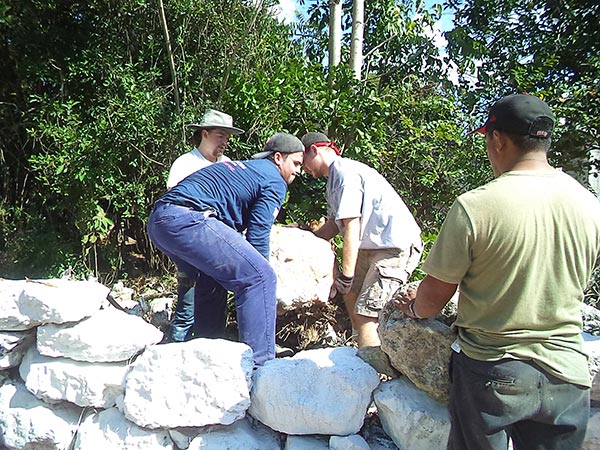
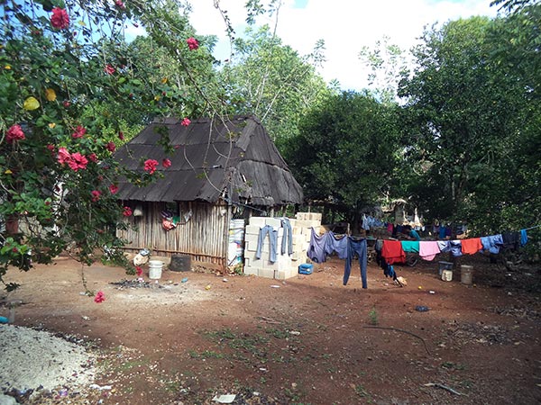
The work project took place near the colonial town of Valladolid, one of several Mexican towns named for cities in Spain. The village where the work took place, Yaxunah, (yax = first or green, nah = house) is home to indigenous residents. The overall goal of the project, partially supported by the Mexican government, is to clean up and repair the town, giving residents a renewed sense of pride and purpose in their home and heritage, thereby stemming the loss of citizens to larger towns. The beginning of this goal was accomplished by the construction of a small museum/interpretive center, outlining customs, history, and practices, including a display of one of their more well-known residents, a shaman who served as the town physician. Mayan artifacts and a life-sized diorama helped depict life in Yaxunah. Many of the residents were at work painting, cleaning, and clearing lots when the group arrived on-site. The primary task at hand was to reconstruct a stone wall that had been incorrectly built. Students got to see this demonstrated first-hand, when they were invited to simply push the wall over. They were instructed by a village foreman how to rebuild the wall without the use of mortar. It is an ancient technique passed down through generations of those living there; apparently, whoever built this one was not a resident. The group was able to reconstruct about 75’ of wall during the project’s duration. In addition, they cleared an area approximately 30’ square for use as a future animal pen. During the work days, lunch was prepared for everyone by ladies who lived there. The project foreman thanked everyone for their efforts and said the goals for our visit were met.
From Yaxunah, the group visited the final archaeological site on the agenda, the seaside ruins of Tulum, the site of a pre-Columbian Mayan walled city. The ruins are situated on 12-meter (39 ft) tall cliffs, along the east coast of the Yucatán Peninsula on the Caribbean Sea. Tulum was one of the last cities built and inhabited by the Maya; it was at its height between the 13th and 15th centuries and managed to survive about 70 years after the Spanish began occupying Mexico. Old World diseases brought by the Spanish settlers appear to have resulted in very high fatalities, disrupting the society and eventually causing the city to be abandoned. One of the best-preserved coastal Maya sites, Tulum is today a popular site for tourists. The temples, once able to be climbed and explored, are now roped off for protection.
This Maya site may formerly have been known by the name Zama, meaning City of Dawn, because it faces the sunrise. Tulum stands on a bluff facing east. Tulúm is also the Yucatan Mayan word for fence, wall, or trench. The walls surrounding the site allowed the Tulum fort to be defended against invasions. The site had access to both land and sea trade routes, making it an important trade hub, especially for obsidian. From numerous depictions in murals and other works around the site, Tulum appears to have been an important site for the worship of the Diving or Descending god. Tulum had an estimated population of 1,000 to 1,600 inhabitants at its peak.
The trip concluded with a day of relaxation at Playa del Carmen, once a quiet fishing village on the coast of the Caribbean and now a popular spot for visitors. This particular trip included staying in four separate locations and one of the fullest schedules of cultural experiences to date.